forum meteorologie, starea vremii, climatologie

Partners

Portal meteorologie   Galerie meteo   Meteo chat   Model WRF-RoMetEx   RSS  
Acum este Joi Mai 02, 2024 12:51 am

Ora este UTC + 2 [ DST ]


Scrie un subiect nou Răspunde la subiect  [ 1390 mesaje ]  Du-te la pagina Anterior  1 ... 83, 84, 85, 86, 87, 88, 89 ... 93  Următorul
Autor Mesaj
 Subiectul mesajului: Re: Prognoza ESTOFEX
MesajScris: Sâm Iun 18, 2016 8:28 pm 
Neconectat
Tornada
Tornada
Avatar utilizator

Membru din: Mie Dec 24, 2008 1:00 pm
Mesaje: 10698
Localitate: Bucuresti
Si unul de intense tornados pentru Bucuresti!


Sus
 Profil  
 
 Subiectul mesajului: Re: Prognoza ESTOFEX
MesajScris: Sâm Iun 18, 2016 8:32 pm 
Neconectat
Ploaie
Ploaie
Avatar utilizator

Membru din: Lun Apr 12, 2010 8:27 pm
Mesaje: 561
Localitate: Bucuresti (Dr.Taberei) / Bruxelles
Cum ar fi un F2 pe la Universitate :)))). Niciodata nu se va intampla. Macar prin IF sa fie ceva interesant vreodata.

_________________
Meteorologie.ro


Ultima oară modificat de Alexanderson pe Sâm Iun 18, 2016 8:33 pm, modificat 1 dată în total.

Sus
 Profil  
 
 Subiectul mesajului:
MesajScris: Sâm Iun 18, 2016 8:33 pm 
Neconectat
EF-5
EF-5
Avatar utilizator

Membru din: Dum Oct 26, 2008 1:00 pm
Mesaje: 25273
Localitate: Slatina OT
Ar avea multe masini to suck up.

Tornadoes e pluralul corect, la fel ca la cartofi potatoes sau mosquitoes-tantarii.

_________________
A venit Ursula, zeita din UE, sa-si primeasca rima.


Sus
 Profil  
 
 Subiectul mesajului:
MesajScris: Sâm Iun 18, 2016 8:57 pm 
Neconectat
EF-5
EF-5
Avatar utilizator

Membru din: Dum Oct 26, 2008 1:00 pm
Mesaje: 25273
Localitate: Slatina OT
Mesoscale si la mine.

_________________
A venit Ursula, zeita din UE, sa-si primeasca rima.


Sus
 Profil  
 
 Subiectul mesajului: Re: Prognoza ESTOFEX
MesajScris: Sâm Iun 18, 2016 9:12 pm 
Neconectat
Weather Guru
Weather Guru
Avatar utilizator

Membru din: Vin Dec 05, 2008 1:00 pm
Mesaje: 36975
Localitate: Bistrita
Radeti voi, dar e cea mai dura prognoza sau mesoscale discussion emisa vreodata de Estofex. Fix pe Romania. Violent tornadoes, giant hail >10 cm...hai ca asa ceva n-am mai vazut.

Si s-ar putea sa fie chiar asa cum zic ei.


Sus
 Profil  
 
 Subiectul mesajului:
MesajScris: Dum Iun 19, 2016 12:41 am 
Neconectat
EF-5
EF-5
Avatar utilizator

Membru din: Dum Oct 26, 2008 1:00 pm
Mesaje: 25273
Localitate: Slatina OT
Baietii ne mai rezerva un 2 pentru duminica-luni. :)

_________________
A venit Ursula, zeita din UE, sa-si primeasca rima.


Sus
 Profil  
 
 Subiectul mesajului:
MesajScris: Dum Iun 19, 2016 2:43 am 
Neconectat
EF-5
EF-5
Avatar utilizator

Membru din: Dum Oct 26, 2008 1:00 pm
Mesaje: 25273
Localitate: Slatina OT
Se razgandesc si upgradeaza la 3 pe zona mea pentru duminica-luni, 8O m-au saturat azi de 2-uri, 3-uri si mesoscale-uri. :lol:

_________________
A venit Ursula, zeita din UE, sa-si primeasca rima.


Sus
 Profil  
 
 Subiectul mesajului: Re: Prognoza ESTOFEX
MesajScris: Dum Iun 19, 2016 11:40 am 
Neconectat
Tornada
Tornada
Avatar utilizator

Membru din: Joi Mai 30, 2013 10:35 pm
Mesaje: 2593
Localitate: Zimnicea
Nicio zi fara cod 3!

_________________
The trifecta of Fimbulvetr, poised to be unleashed: AMOC collapse - Beaufort Gyre Release - Heinrich Event. System reset.


Sus
 Profil  
 
 Subiectul mesajului: Re: Prognoza ESTOFEX
MesajScris: Dum Iun 19, 2016 12:09 pm 
Neconectat
Weather Guru
Weather Guru
Avatar utilizator

Membru din: Vin Dec 05, 2008 1:00 pm
Mesaje: 36975
Localitate: Bistrita
Oare s-o tina tot in 3-uri pana miercuri? E chiar o perioada memorabila.


Sus
 Profil  
 
 Subiectul mesajului:
MesajScris: Dum Iun 19, 2016 8:23 pm 
Neconectat
EF-5
EF-5
Avatar utilizator

Membru din: Dum Oct 26, 2008 1:00 pm
Mesaje: 25273
Localitate: Slatina OT
Cred ca MD-urile au devenit un fel de nowcasting al Estofex.

_________________
A venit Ursula, zeita din UE, sa-si primeasca rima.


Sus
 Profil  
 
 Subiectul mesajului: Re: Prognoza ESTOFEX
MesajScris: Lun Iun 20, 2016 10:41 am 
Neconectat
Weather Guru
Weather Guru
Avatar utilizator

Membru din: Vin Dec 05, 2008 1:00 pm
Mesaje: 36975
Localitate: Bistrita
Nu se poate asa ceva, inca in lvl 3. :lol:

Imagine

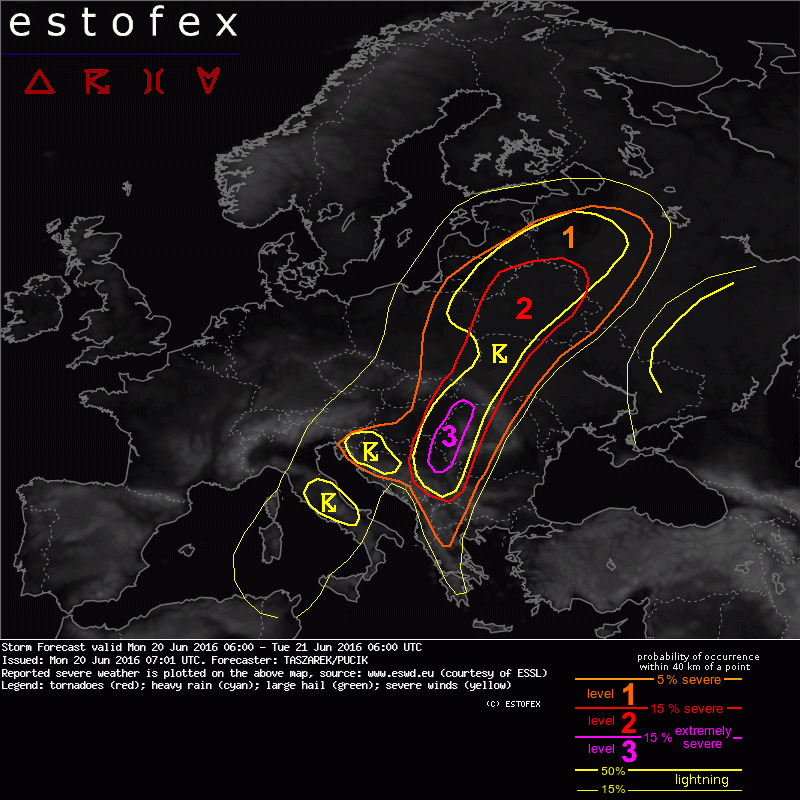
A level 3 was issued for W Romania, E Hungary, NE Serbia, mainly for large to very large hail, damaging wind gusts, excessive precipitation and tornadoes.

A level 2 was issued for Belarus, E Lithuania, W Ukraine, W Romania, E Hungary and Serbia mainly for large to very large hail, damaging wind gusts, excessive precipitation and tornadoes.

A level 1 was issued for area extending from W Russia up to W Balkan Peninsula mainly for large hail, severe wind gusts and excessive precipitation.

SYNOPSIS

Cut-off over Italy weakens and geopotential heights are constantly rising over most of the S, E and SE Europe. A thermal boundary (a quasi-stationary wavy front) within northwardly moving tropical highly unstable air mass extends from Baltic countries, trough E Poland, E Hungary up to Croatia. A main polar jet stream is located between N Atlantic and Benelux. A sub-tropical jet streak stretches longitudinally from S Italy up to Belarus on the north-eastern flank of the fading Italian trough. In its northern section, a low-level jet develops over Belarus within a passage of the shortwave trough. SW Europe is under influence of a broad ridge while another high is located over W Russia. The main thunderstorm area runs along thermal boundary between tropical and polar air mass. A few more or less pronounced short-waves induce temporarily enhanced synoptic-scale lift. Severe and extremely severe thunderstorms are expected in the corridor from Serbia up to Belarus, where a a highly unstable warm sector is overlapped by a jet streak and thus strong vertical wind shear.

...area extending from W Russia up to W Balkan Peninsula...

Rich boundary layer's moisture on the eastern side of the quasi-stationary frontal boundary combined with ongoing evapotranspiration and regional confluent flow results in mixing ratios up to 13-14 g/kg. Given an overlap with vertical lapse rates exceeding 7 K/km , ML CAPE develops mostly up to 1500-2000 J/kg and locally even > 3000 J/kg. A jet streak covering warm sector on the eastern side of the frontal boundary results in a high DLS up to 25-30 m/s and locally provide a rare and an extreme overlap with high thermodynamic instability (DLS*WMAX values ~ 2000 m2/s2) in the corridor from W Ukraine and Serbia. Any thunderstorm developing in this environment may very quickly become an isolated supercell (SRH values from 250-400 m2/s2) with a potential of producing giant hail, damaging wind gusts and significant tornadoes given increasing LLS up to 10 m/s in the late afternoon hours. In addition, a strong airflow at 700 hPa and resulting 15-20 m/s MLS may potentially organise convection into bowing features where hurricane-force wind gusts are possible. Although there is not a source of significant large-scale lift, a long-lived squall line cannot be ruled out. In this scenario, thunderstorms would produce a widespread damage due to severe wind. In the northern area of lvl 2, although a thermodynamic instability is lower, a similar scenario with an extremely severe supercells is possible. Tornado threat seems to be high in this area due to a more favourable wind profile with extreme SRH values (400-600 m2/s2) and stronger LLS during the day (> 15 m/s). In addition, the area is under influence of the passing shortwave. One or two MCS in the late evening hours are possible. In addition to afromentioned phenomena, a moist vertical profile with PW exceeding 30-35mm may result in a torrential rain produced by supercell, multicell clusters and MCS in the evening hours. A highest threat is confined to a meso-low located over E Poland where a motion of the thunderstorms will be slower.

The main limiting factor for this forecast is whether a CI will take place. Most of the NWP model scenarios agree on the CI due to local convergence zones and orographic lift in the corridor from Serbia to W Ukraine. However, remaining cloud-cover from the nighttime thunderstorms may inhibit diurnal heating and thus do not allow thermals to pass CIN zone. Although we are aware of this risk, a level 3 is issued due to possibility of extremely severe thunderstorms in an extreme overlap of high DLS and very high CAPE. The more uncertain areas with environment favourable for severe storms include E Poland and E Belarus where dew point are lower and NWP models are more conservative in terms of CI over this areas. Therefore, we include these areas in the lvl 2 areas, but they cover 15% probability for lightning.


Sus
 Profil  
 
 Subiectul mesajului: Re: Prognoza ESTOFEX
MesajScris: Lun Iun 20, 2016 10:44 am 
Neconectat
Ploicica
Ploicica
Avatar utilizator

Membru din: Sâm Oct 31, 2015 11:16 am
Mesaje: 349
Wow! E un record! Poate mai vine o supercelulă pe Transilvania ca ieri!(ESTOFEX a dat în centru ieri tot LVL 2!)

Trimis de pe al meu Lenovo S860 folosind Tapatalk


Sus
 Profil  
 
 Subiectul mesajului: Re: Prognoza ESTOFEX
MesajScris: Lun Iun 20, 2016 10:47 am 
Neconectat
Weather Guru
Weather Guru
Avatar utilizator

Membru din: Vin Dec 05, 2008 1:00 pm
Mesaje: 36975
Localitate: Bistrita
Macar azi sa fie ziua Clujului, in pana mea.


Sus
 Profil  
 
 Subiectul mesajului: Re: Prognoza ESTOFEX
MesajScris: Lun Iun 20, 2016 10:52 am 
Neconectat
Tornada
Tornada
Avatar utilizator

Membru din: Joi Mai 30, 2013 10:35 pm
Mesaje: 2593
Localitate: Zimnicea
E incredibil cate furtuni pot sa fie in vestul si nord-vestul tarii in aceasta luna!

_________________
The trifecta of Fimbulvetr, poised to be unleashed: AMOC collapse - Beaufort Gyre Release - Heinrich Event. System reset.


Sus
 Profil  
 
 Subiectul mesajului: Re: Prognoza ESTOFEX
MesajScris: Lun Iun 20, 2016 10:54 am 
Neconectat
Ploicica
Ploicica
Avatar utilizator

Membru din: Sâm Oct 31, 2015 11:16 am
Mesaje: 349
Şi în plus violente!

Trimis de pe al meu Lenovo S860 folosind Tapatalk


Sus
 Profil  
 
Afişează mesajele de la anteriorul:  Sortează după  
Scrie un subiect nou Răspunde la subiect  [ 1390 mesaje ]  Du-te la pagina Anterior  1 ... 83, 84, 85, 86, 87, 88, 89 ... 93  Următorul

Ora este UTC + 2 [ DST ]


Cine este conectat

Utilizatorii ce navighează pe acest forum: Niciun utilizator înregistrat şi 3 vizitatori


Nu puteţi scrie subiecte noi în acest forum
Nu puteţi răspunde subiectelor din acest forum
Nu puteţi modifica mesajele dumneavoastră în acest forum
Nu puteţi şterge mesajele dumneavoastră în acest forum
Nu puteţi publica fişiere ataşate în acest forum

Căutare după:
Mergi la:  
Termeni şi condiţii
Powered by phpBB® Forum Software © phpBB Group
Translation/Traducere: phpBB România
phpBB SEO