Ultima rulare ECMWF a devenit frumoasa pentru noi. Sa fie un cadou de Craciun?

Dupa un asalt tropical in ultima zi din an, urmeaza o racire brusca, eventual un viscol pe 2 ianuarie ?, urmat de advectie de aer polar continental. Desi amplasarea blocajului vestic este cam mult catre vest si ar putea sa anuleze imediat racirea prin impingerea unui nucleu rece catre UK si sa ne arunce din nou in primavara, exact cum s-a intamplat saptamana aceasta, structura sinoptica proiectata de modelul european este extrem de interesanta si de urmarit, cu probabilitatea de a genera evenimente speciale, cu succesiuni calde si reci extreme.

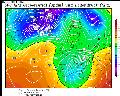
Vreau sa merg pe acest model pe termen mediu si lung pentru ca este o idee mai consecvent decat GFS, care in ultimele zile are operationala ori peste cel mai cald membru, ori sub cel mai rece.
Si Bastardi e optimist: "WELL HERE WE GO AGAIN! SEVERE COLD LOOMING FOR MUCH OF EUROPE FIRST 2 WEEKS OF THE NEW YEAR!
While we are in a bit of a break over the next week, a reload of excess cold is on the way for the first 2 weeks of the New Year, that will challenge the recent cold as far as how cold it was against the normals. Severe cold is likely to cause major hardship across much of the continent and when we stand back and look at this, we will say that our forecast at least caught the SPIRIT OF THE WINTER, if not the law."


 Vizualizat de 707 ori")

