Hai sa mai lasam off topicul sever la o parte si discutiile care n-au nici o legatura cu vremea si sa ne concentram pe ce se va intampla. Daca as fi eu admin, ce v-as face.

Pacat ca nu mai am timp de forumul asta.

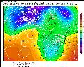
Estofex: ... Bulgaria, Southern Romania ...
Moderate instability built-up is forecast thanks to the diurnal heating and slow upward motion in the left-exit region of strong mid and upper level flow. MLCAPE values might exceed 1000 J/kg, with some models being even more optimistic. Strong flow might sustain DLS values in the range of 15-25 m/s, with the highest values over Central Bulgaria. With slightly backed flow thanks to the approach of the trough in the lower troposphere, SREH values will reach, especially towards the evening, more than 100 J/kg in the 0-3 km layer. Such conditions are conducive of well organised mutlicells and supercells, capable of large hail and severe wind gusts. Limiting factor will be the forcing, however, with GFS breaking out only very little precipitation over Bulgaria. WRF model seems to be more optimistic with isolated spots of precipitations. The highest storm coverage is expected over Southern Romania towards the evening. Strong convergence, deep layer of unstable airmass and low LFCs are suggestive that Bulgaria will also see some convective initiation. With the questions remaining about the degree of storm coverage, only a high-end Level 1 is issued, but an upgrade might become necessary later on.
Deci sudul tarii ar trebuie sa si-o ia astazi, posibil chiar serios.